
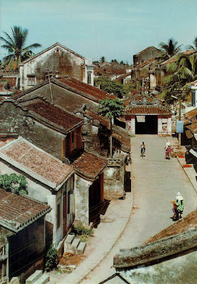
Location : Hoi An is located approximately 30 km south of Da Nang, the fourth largest city in Vietnam, where the estuary of the Thu Bon River (the largest in Khannam Danang Province) flows into the East China Sea. Today, Hoi An port has a simple quay and the water is shallow. However, between the 16th and 18th centuries, the city was a prosperous international trading port and its seashore had a protective formation of sandbanks surrounding a bay, which provided a safe anchorage for ships in those days.
The name "Hoi An" refers both to the town and the surrounding community which includes several villages (xa). Present-day Hoi An consists of 6 villages (Ming Phuong, Hoi An, Kochai, Dong An, Zie Hom, Ho Hua) and the town of Hoi An.
The town of Hoi An is composed of 3 districts (phuong). These are divided into smaller units called khu, vuc, xa. There are also neighborhoods (to) which are the smallest units.
Outline of the Heritage : Hoi An, formerly called Fai Fo, was a port town used as a relay trading base for Southeast Asia. Wooden tradesmen's houses, Chinese merchants' club-houses , Emperor Kwang's Shrine, etc., stand along Kyanhou, running parallel with the Thu Bon River, and facing two streets: Nguyenchiminhkai and Nguyentaihok. It is supposed there was a Japanese town, similar to the o-ne in Ayutthaya,Thailand, between the 15th and 16th centuries, and Imari ceramic ware was discovered as evidence of the trading. Although the town has come to assume its present appearance since the latter half of the 18th century, the mixture of various cultures it embraces has been attracting a great number of tourists.
No comments:
Post a Comment